![]()
Goal
Promote the utilization of readily available satellite observations coupled with models to better understand complex processes of the Earth’s climate and environment.
Research Interest
Satellite product development
Readily available satellite imagery are calibrated to generate more reliable datasets tailored to Philippine conditions. In the case of Diwata-1 and Diwata-2, algorithms are developed to translate the imagery to standard geophysical parameters and higher level remote sensing products.
Land Cover/Land Use Change & Modelling
Land use and land cover changes are investigated through classification of multi-temporal satellite images. Classification maps are analyzed and integrated with ancillary datasets to determine change drivers and model change trajectories.
Laguna de Bay Lake and Watershed Monitoring
The interaction between human activities and the environment in the Laguna watershed are studied. One phenomenon being investigated is wind-induced resuspension of suspended matter in the lake, which may affect lake productivity. Modeling of future urban sprawl in the cities and municipalities surrounding the Laguna de Bay is also being done.

Drought Monitoring and Forecasting
Satellite-derived agricultural drought index was developed to monitor agricultural drought events in the Philippines. Drought forecasting through statistical and dynamical models is improved by understanding the influence of different meteorological and environmental conditions to agricultural drought.
Remote Sensing for Agricultural Applications
Satellite data and models are used to derive agricultural land classification maps, cropping calendars, optimal planting window, and yield forecasts.
Surface Water Balance Observations
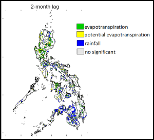
The contributions of Potential Evapotranspiration, Evapotranspiration, Rainfall and Soil Moisture in the Philippine surface water balance is being investigated by multi-temporal data from geostationary and polar orbiting satellites.
Forest Cover Change and Drivers
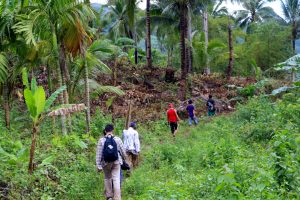
Remote sensing offers an objective and reliable way to monitor forest cover changes, especially forest loss and gain. In conjunction with the conduct of socio-economic validation and historical survey, remote sensing data deepen our understanding on the anthropogenic and natural drivers with regards to forest change.
Aquaculture Site Suitability and Mapping
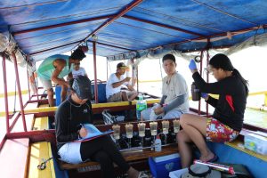
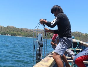
Satellite remote sensing and in situ measurements of water quality parameters are used to identify suitable sites for aquaculture. The resulting thematic maps are tools that can aid in aquaculture management.
Fish Probability Mapping
Fish probability maps can be derived from the underlying relationships between the fish species and the characteristics of their environment (e.g. measures of chlorophyll-a concentration and sea surface temperature). This is done through the combination of geographic information system (GIS) methods, remote sensing techniques and spatial distribution modeling.
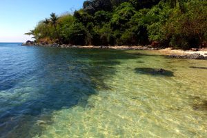
Coastal Habitat Assessment
Assessment of impacts of both natural hazards and anthropogenic activities on coral reefs, mangroves and seagrass are conducted.
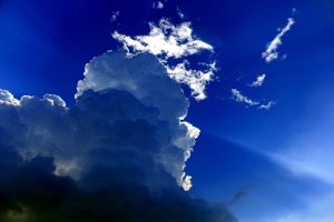
Remote Sensing of Clouds and Aerosols
Geostationary and polar-orbiting satellites are utilized for atmospheric studies focusing on the detection of potential rainfall areas and the direct and indirect effects of aerosols on local temperature.
2018
Ishida, T. A., Kurihara, J. B., Viray, F. C., Namuco, S. J., Paringit, E. J., Perez, G. undefined, … Marciano, J. undefined. (2018). A novel approach for vegetation classification using UAV-based hyperspectral imaging. Computers and Electronics in Agriculture, 144, 80–85. doi: 10.1016/j.compag.2017.11.027 (ISI)
2017
JC Comiso, RA Gersten, LV Stock, J Turner, GJ Perez, and K Cho, “Positive Trend in the Antarctic Sea Ice Cover and Associated Changes in Surface Temperature,” Journal of Climate 30, 2251-2267 (ISI)
2016
GJ Perez, et al., “Forecasting and monitoring agricultural drought in the Philippines,” International Archives of the Photogrammetry, Remote Sensing and Spatial Information Sciences – ISPRS Archives 41, pp. 1263-1269
RAG Faelga, EC Paringit, GJ Perez, (…), FAM Tandoc, MV Malabanan, “Mangrove plantation forest assessment using structural attributes derived from LiDAR data,” International Archives of the Photogrammetry, Remote Sensing and Spatial Information Sciences – ISPRS Archives 41, pp. 617-623
RAG Faelga, EC Paringit, GJ Perez, (…), FAM Tandoc, GP Zaragosa, “Validation of the separability measure for Rhizophoraceae and Avicenniaceae using point density distribution from LiDAR,” Proceedings of SPIE – The International Society for Optical Engineering 9879,98791F
B Fallarcuna, GJ Perez, “Forest cover dynamics in the Philippines from Landsat-derived forest cover dataset (2000-2012),” Journal of the Philippine Geosciences and Remote Sensing Society Volume 2
RAG Faelga, EC Paringit, GJ Perez, (…), FAM Tandoc, GP Zaragosa, “Separability and Variability of Rhizophoraceae and Avicenniaceae in Natural Mangrove Forest Using Point Density Distribution from Lidar Data,” Journal of the Philippine Geosciences and Remote Sensing Society Volume 2
B Fallarcuna, GJ Perez, “Quantifying forest cover changes in the Philippines from 2000-2012 from Landsat-derived global forest cover dataset,” ACRS 2015 – 36th Asian Conference on Remote Sensing: Fostering Resilient Growth in Asia
GM Macam, GJ Perez, “Evaluating the potential of downscaled CFSV2 for drought forecasting using MODIS and TRMM observations,” ACRS 2015 – 36th Asian Conference on Remote Sensing: Fostering Resilient Growth in Asia
EMC Leonardo, GJ Perez, “Predicting abundance of different tuna species in the Philippines,” ACRS 2015 – 36th Asian Conference on Remote Sensing: Fostering Resilient Growth in Asia
EMR Macapagal, GJ Perez, “Evaluation of Soil Moisture Estimates Derived from the Advanced Microwave Scanning Radiometer 2 (AMSR2) in the Philippines,” ACRS 2015 – 36th Asian Conference on Remote Sensing: Fostering Resilient Growth in Asia
RO Olivares, M Macapagal, GJ Perez, “Extreme value analysis of evaporative stress index as input to assess agricultural drought risk in the Philippines,” ACRS 2015 – 36th Asian Conference on Remote Sensing: Fostering Resilient Growth in Asia
J Pangasinan, MJ Felix, GJ Perez, “Performance of empirical Cl-a derivation algorithms on the coastal waters of Bagac and Polilio,” ACRS 2015 – 36th Asian Conference on Remote Sensing: Fostering Resilient Growth in Asia
RB Badrina, JS Combinido, GJ Perez, “Impact of land use change on weather research and forecasting (WRF) output: A case study for the Philippines,” ACRS 2015 – 36th Asian Conference on Remote Sensing: Fostering Resilient Growth in Asia
MJ Felix, J Pangasinan, GJ Perez, “Estimation of chlorophyll-a concentration on oligothropic open waters of the Philippines: A case study for Polilio,” ACRS 2015 – 36th Asian Conference on Remote Sensing: Fostering Resilient Growth in Asia
2014
GJ Perez and JC Comiso, “Seasonal and Interannual Variability of Philippine Vegetation as Seen from Space,” Philippine Journal of Science Vol. 143 No. 2 pp. 147-155 (ISI)
DM Dela Torre and GJ Perez, Phenology-based classification of major crops areas in Central Luzon, Philippines from 2001-2003,” 35th Asian Conference on Remote Sensing 2014, ACRS 2014: Sensing for Reintegration of Societies
JP Punay, GJ Perez, “Evaluation of MODIS Cloud Product-derived rainfall estimates,” 35th Asian Conference on Remote Sensing 2014, ACRS 2014: Sensing for Reintegration of Societies
2013
EM Macapagal and GJ Perez, “Soil moisture studies in the Philippines using AMSR-E/AMSR2,” 34th Asian Coference on Remote Sensing 2013, ACRS 2013 4, pp. 3322-3329
J Punay and GJ Perez, “Rainfall retrieval algorithm using MODIS cloud mask and cloud products,” 34th Asian Conference on Remote Sensing 2013, ACRS 2013 2, pp. 1494-1500
MS STUDENTS GRADUATED
- Marco Macapagal, MS Environmental Science (June 2017), “Developing an Agricultural Drought Index in the Philippines using MODIS NDVI and LST data”
- Daniel Marc dela Torre, MS Environmental Science (June 2016), “Monitoring and Detection of Interannual Crop Land Use Changes in Central Luzon Using Novel Satellite-based Classification Technique”
- Brent Fallarcuna, MS Environmental Science (June 2016), “Analysis of Forest Loss Rates, Trends and Its Implications to Key Deforestation Drivers and Forest Management from 2000-2012: A Case Study of Three Municipalities in the Philippines”
- Harry Casimir E. Merida, MS Environmental Science (December 2018), “Assessing the Effectiveness of Nipas in Conserving the Forest of Batanes”
- Cindyleen Grieta, MS Meteorology (June 2016), “Climatology and Variability of Sea Surface Temperature in the Philippine Domain and its Relationship with ENSO, MJO, and PDO”
- Jason Punay, MS Meteorology (June 2015), ” Rainfall Estimates from Moderate-Resolution Imaging Spectroradiometer (MODIS) Cloud Products”
- Erika Mari Macapagal, MS Meteorology (December 2014) “Analysis of Trends and Variability of Philippine Soil Moisture from 2002-2014 Using Passive Microwave Satellite Data”
- Preethika Jayakodi, MS Meteorology (March 2013) “Influence of La Nina on Sri Lanka Rainfall“
- Angelo Benedict R. Ragunjan, MS Meteorology (November 2017) “Influence of Selected Hydrometeorological Variables to Agricultural Drought”
- Adrian C. Chummac, MS Meteorology (June 2018), “Weather as Control of Planting Window for Rainfed Corn in Ifugao”
- Jasper T. Madalipay, MS Meteorology (November 2018), “Effects of Aerosol Optical Properties, Variations and Dynamics on the Radiative Forcing: Focus on Metro Manila”
MS CANDIDATES
MS Environmental Science
-
- Regine Faelga
- Ellen Mae Leonardo
- Louisse Anne Fulgencio
- Francisco Miguel Felicio
- Marites Joven
- Arvin Caro
MS Meteorology
-
- Redmund Nacario
- Jophet Flores
- Raymond Jess Goliat
- Shiverley Benedict Feland T. Dolores
- Charlie S. Andan
- Michael Angelo P. Valete
- Rotsen B. Labrisores
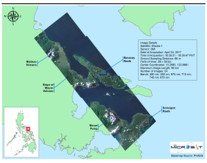
Remote Sensing Product Development (Project 5) of PHL-MICROSAT Program
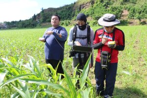
The Remote Sensing Product Development is one of the project components of the PHL-Microsat program, which built and operates the country’s first microsatellites Diwata-1 and Diwata-2. The project aims to develop algorithms for deriving geophysical parameters from the satellite imagery. High-quality spectral data of different crops, land and water surfaces are collected for ground-truthing and algorithm enhancement. The project also initiates and implements regular science meetings to provide updates on the satellite product development.
Remote Sensing of Coastal Habitats and Stressors (Project 9) of CoRVA
The (CoRVA) Program aims to assess the condition of the reefs in NIPAS sites in terms of extent, health, biodiversity and connectivity. CoRVA 9, as one of its components, utilized remote sensing technology to determine the extent and changes of coastal habitats in the NIPAS sites as well as the impact of sedimentation derived from the watershed activities.
Suitability assessment and database development for enhanced mussel culture using geospatial technologies (Project-SSAM)
This Project is a research funded by DOST-PCAARRD through Grants-In-Aid Program and is currently implemented by University of the Philippines Visayas and University of the Philippines Diliman. The project aims to assess and analyze suitable areas for mussel in the Philippines using geospatial technologies.
Philippine Coral Reef and Mangrove Remote Sensing (PhilCoMaRS)
PhilCoMaRS is a joint project of UP and DENR which aims to produce user-friendly coral reef and mangrove resource maps which can be consulted in a regional and provincial scale. This is being done with the use of remote sensing techniques on Landsat satellite imagery reinforced with field validations. The effects of the warming ocean temperature due to past major ENSO events to coral health are being characterized to evaluate the resilience of this coastal habitat.